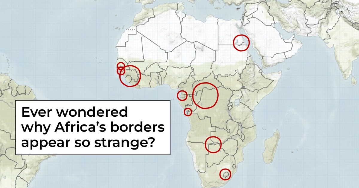
Instead of following natural landscapes or past historical lines, many of its borders are remarkably linear in some areas and irregular in others, dissecting mountain ranges, rivers, and even communities.
The origin of most of these artificial borders dates back to the Berlin Conference of 1884-1885, where European powers divided the continent without any African nations included or represented.
In this visual explainer, Al Jazeera explores the stories behind some of the continent’s most peculiar borders.
Why hasn’t anyone claimed Bir Tawil?
Looking at northeastern Africa, there lies a 2,000sq-km uninhabited, arid piece of land that neither Egypt nor Sudan claims as theirs.
In 1899, Britain set a straight-line border at the 22nd parallel, separating Egypt and Sudan, which were under British control. However, in 1902, for geopolitical and administrative reasons, Britain reassigned the coastal Hala’ib Triangle to Sudan and Bir Tawil to Egypt.
Years later, after their independence, Egypt insisted on the 1899 agreement, while Sudan argued for the 1902 demarcation, leaving Bir Tawil unclaimed by both.
Egypt has controlled the Hala’ib Triangle since 2000, but the dispute continues.
Why is The Gambia so narrow?
As you journey along Africa’s western coast, you will find a narrow slice of land surrounded by Senegal – this is The Gambia, Africa’s smallest mainland country.
After initially being a hub in the transatlantic slave trade, The Gambia became a British colony until 1965. Its borders were formalised in 1889, establishing British control around 16km on either side of the Gambia River.
A popular tale suggests that British forces used cannonball firings to set the boundaries, though records indicate disagreements by local rulers during the 1891 commission set to clarify them.
Why is Cabinda part of Angola?
Traveling south, Cabinda is an Angolan province cut off by a narrow strip of the Democratic Republic of the Congo.
During the Berlin Conference, Cabinda was recognised as Portuguese territory but later administratively merged with Angola. When Portugal left African territories in 1975 under the Alvor Agreement, Cabinda was merged with Angola for its offshore oil reserves.
Why does Namibia have a narrow panhandle?
Moving into Southern Africa, a slender protrusion from Namibia is known as the Caprivi Strip.
Germany traded its claims to Zanzibar for Heligoland and the Caprivi Strip in 1890, aiming to create a shortcut through the Zambezi to its colonies. However, due to a miscalculation that overlooked Victoria Falls, this plan was thwarted.
Why is Lesotho surrounded by South Africa?
Nestled in Southern Africa among the mountains, Lesotho exists entirely surrounded by South Africa.
Rich in history, HChe Basotho, under King Moshoeshoe I, leveraged the highlands for protection. Seeking protection from the Boers, Lesotho became a British protectorate in 1868.
Aligning with the establishment of the Union of South Africa, Lesotho maintained British rule until it gained independence as Lesotho in 1966.
Why are there three African countries named ‘Guinea’?
Three West African countries include “Guinea” in their names:
- Guinea, known historically as French Guinea, gained independence in 1958.
- Guinea-Bissau, formerly Portuguese Guinea, became independent in 1974, adding “Bissau” for differentiation.
- Equatorial Guinea, previously Spanish Guinea, attained independence in 1968, including “Equatorial” due to its location near the equator.
The fourth country, Papua New Guinea, was named by a Spanish explorer for its perceived resemblance to West Africans when gold from the region was used for the British guinea coin.
Why are there two Congos?
西战 River lies two countries, both named after it: the Democratic Republic of the Congo and the Republic of the Congo.
Belgian and French colonial powers each established territories along the river, named for the Kingdom of Kongo that once thrived there.
